09/09/2004 to 09/27/2004
This trip was to the North & West, so we're calling it The Northwest Trip.
We drove through Colorado, Nebraska & Iowa, then into Minnesota to see the kids, our grandson, relatives and friends.
We left home on 9/7 and got into Minneapolis area on 9/10. The first 4 nights we stayed with Peter & Livia who have just added another house to their existing house. Very nice. The next 3 nights we spent at Wendy's, driving her crazy.
After leaving Minnesota, we headed west. The points of interest we wanted to see were specifically Badlands, Devil's Tower, Little Bighorn, Mt. Rushmore, Yellowstone and the Tetons. We did them all, plus a couple side trips. What a good time.
- Fort Kearney - Nebraska
- Minnesota Group
- Corn Palace
- Chamberlain, SD
- Badlands National Park
- Mount Rushmore National Park
- Wind Cave National Park
- Devils Tower
- Little Bighorn Battlefield
- Yellowstone National Park - Day 1
- Yellowstone National Park - Day 2
- Yellowstone National Park - Day 3
- Grand Teton National Park
- Grand Tetons - Death Canyon Trail
- Jackson Hole
We stopped at Ft. Kearney in Nebraska on our way to Minnesota.
It is a State Historical Park several miles southeast of Kearny, Nebraska.
It has a very nice interpretive center with excellent artifacts from the Oregon Trail days, a restored blacksmith's shop, a stockade, and beautiful grounds in which to picnic or relax.


Replicated Sod Building. Yes, grass is growing on the roof

The stockade was not for people, it's where they put the cattle and horses at night to keep them from being stolen
We tried not to embarrass our family members too much, but we just had to bring in a couple shots of Quinn, Brian & Jenny.
Though there aren't many pictures the subject matter is all important.

Quinn seems more interested in George's finger than the camera

Brian, Jenny & Quinn

Quinn really does smile, just not when we're taking his picture. He was such a sweetie on this trip
The Corn Palace in Mitchell, SD.
The facade is all done with corn, and there's a new design every year.
It's pretty amazing what folks will think of to get attention.


Chamberlain sits in a nice rolling valley along the Missouri River and was a stopping point for Lewis & Clark.
We really enjoyed the replicated keelboat and talking to the men who man these as they recreate the route of the Core of Discovery.

Sign describing the keelboat and it's use during the Core of Discovery Expedition

Bicentennial Sign

Lewis & Clark stopped in Chamberlain on their expedition. We happened to be there on the bicentennial and saw the keelboats

This is a recreation of a keel boat used by the Lewis & Clark expedition as it went down the Missouri


The first area we visited was bleak and parched.
We did a little hike called Notch Trail. It was only about a mile to an overlook, but we were baking in about 120 on the floor of the valley. Notice the nice little ladder part.
After the hike we just drove through the park, and there was a lot of green.
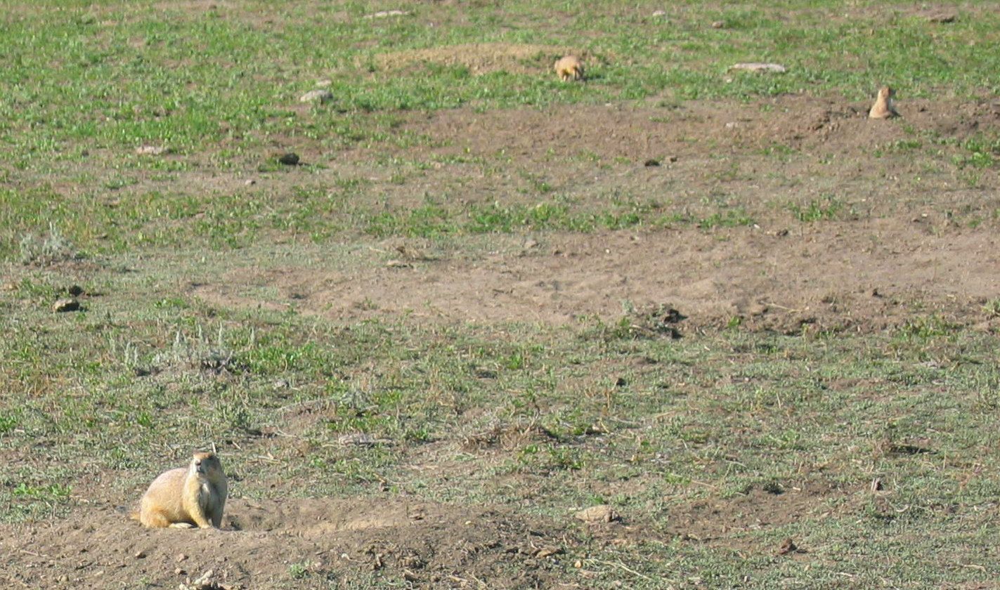
Buffalo were everywhere, and there's a section called Robert's Prairie Dog Town.
Hundreds of mounds and prairie dogs popping out of holes or diving down into holes. Or just standing up and chirping.
After we left Badlands Park, we stopped by Wall Drug, another tourist trap of renown.


See the notch? Hence the name

Ya, that's my butt going up the ladder to the narrow ledge

We hiked in 120 degree heat just to see this? Boy, are we dumb

Bleak, rugged landscape


Antelope - see not all the Badlands is bleak

There were a lot of buffalo. These guys are huge


This is to give some idea of the vast numbers of prairie dogs. All those little brown bumps are mound or dogs


The Famouse Wall Drug. It's really several buildings with stores, food, etc.
After the Badlands, we continued to head west to get to our next tourist site, Mt. Rushmore.
We found a cute cabin in Hill City, SD at Creek Side Resort.
It had a miniature golf course and a little stream out back for fishing. Looked like it would be a lot of fun if we had more time.
But we were in serious TOURIST MODE so no fooling around. Get a night's sleep then on to the giant heads

Our little cabin at Creekside Resort in Hill City, SD

The place was fully furnished. Even had a gas fireplace


This is your first glimpse of Mt. Rushmore as you drive up to the park


This facade is relatively new, and I think it looks like something out of a fascist propaganda movie - stark and uninviting


Remember North By Northwest with Cary Grant? Same wall, same scene, only no Cary or Eva Marie

As you walk around the monument you see each face singularly at certain points, then another comes into view to join it


This is just a shot of part of the walkway around the monument. Very pretty setting
Next stop after Mt. Rushmore was either Jewel Cave or Wind Cave.
Jewel was closed for the season, so we headed to Wind Cave National Park for a cave tour.
Part of our drive down was on the Peter Norbeck Scenic Highway. It winds down through to Custer State Park, a really lovely place we would like to do again.
The tour of the cave was a couple hours off, so we drove through the park.
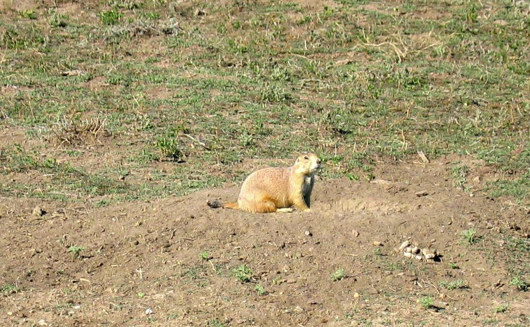
Lots of critters - buffalo, deer, and tons of prairie dogs. Also, mangy coyotes.
Yes, they have mange. There's a study being done on them to determine just why they have mange. They're pretty scruffy looking as you can see.

We took 87 which also is part of the Peter Norbeck Scenic Highway. There are lots of these one-lane bridges

The sign says Sound Horn. The road on the other side is a blind curve

Low Narrow Tunnel. Falling Rocks. Sound Horn. Think there's enough warning signs?

As we drove into Custer State Park who do we see sauntering up the road but Mr. Bighorn Sheep

He placidly moves along the road next to us

Nice shot of the Scenic Byway


Buffalo were frequent along the road. We took more shots of them, but one buffalo looks like another after a while


There were lots of deer along the roadway as well

One of the mangy coyotes


More paririe dogs. I've only included 2 shots, but we took dozens. They're so cute to watch


We also saw wild turkeys roaming around in the fields
Ever since "Close Encounters of The Third Kind" I've wanted to see Devils Tower. I was not disappointed.
It's a beautiful piece of nature and the surrounding park is a joy to walk through.
We strolled along the short path that encircled the Tower.
Took our time enjoying the various views of the monument and the pine forest through which the path meanders.
One of the things we noticed immediately was how peaceful and calming the area is.


The park is in the middle of nowhere, but as you approach, it's a surreal sight

The closer you get, the more intriguing it looks. And big. Let's not forget BIG


The sign tells a little of the history of Devils Tower

These formations are referred to as columns, caused by water and wind errosion.


Some of the lovely pines surrounding the base


As we were leaving a flock of wild turkeys was crossing the road
Being history nuts, we naturally had to stop at Little Bighorn Battlefield.
We bought the CD and did the interpretive drive, which has been updated and includes the Indians remembrances.
It's very sad to see how bad leadership and arrogance lead to so many deaths.


This is the monument to the fallen soldiers and scouts


The Indian's Memorial to the fallen on both sides.

This gives a small idea of the vast emptiness and rolling hills that are the setting for the battle

Thousands of Indians were camped in this valley the day of battle

There are so many of these headstones - one for each man and the area he fell


This is actually a national cemetary, much like Arlington. Veterans from any era can request to be buried here

This is the hill where Custer and the remains of his outfit fought. Custer's remains were moved to West Point in 1881

After Little Bighorn we headed to Yellowstone National Park.
We took 14A from Sheridan to Cody, a rather scenic route.
Lots of twists, steep grades, and great scenery.
The weather turned windy, wet and a little snowy, and at the top of the mountains we got a couple great shots, including a huge cloud that seemed to sit on the mountain.
We stayed the night in Cody, then back on the road to Yellowstone.
We took the Chief Joseph Scenic Byway and got to the NE Entrance of the park around 10:30.
That first day we saw mountain sheep wandering the road, Tower Falls, elk, and a couple bears (from quite a distance).
We drove over to Canyon Village thinking we might stay at the lodge there, but it was closed for the season.
We did have lunch and get a shirt for Quinn, then drove around some more.

This is 14A on the way to Cody. Yes, we had snow

Here's that cloud setting on top of themountain

Chief Joseph Scenic Highway

That little black blob and that little brown blob are bears

These are part of a pretty big group of females & kids that were meandering all over the road


What you don't see is the ranger patiently herding theme along

This is just one of several elk herds we saw

The herd in the other shot belongs to this guy

Another big male elk, but he doesn't have a herd of females

Tower Falls
We stayed the night at Yellowstone Lodge in West Yellowstone. Very nice folks running it.
This is a nice little town and I wish we were spending more time just looking around but we're pretty tired.
By the time we finished dinner we were ready for bed.
Somewhat rested we are set for Day 2 of the Yellowstone Expedition.
It takes forever to get anywhere because people are crawling along the road looking at things.
Or else a buffalo is strolling down the middle of the lane, and you don't pass a buffalo.
We figured they have a morning meeting to decide who stops traffic and poses for tourists. The loser has to walk the streets.
We also saw Gibbon Falls, Beryl Springs, Artist Paintpot, Norris Geyser Basin, and took Mammoth Terrace Driver


Here's that buffalo holding up traffic

Buffalo Poser

Sharon at *%, hack, #, caugh, choke Beryl Springs

Artist Paintpot Hot Springs

Another hot spring at Artist Paintpot

Artist Paintpot


George & Sharon at Echinus Geyser

Echinus Geyser errupting

Echinus Geyser still errupting

Echinus Geyser finished errupting. I left out the other 12 shots of steam

Just some pretty scenery

Gibbon Falls

Gibbon River

Ya, she's lost again


Huff & Puff Geyser


Norris Geyser Basin. Bleak isn't it?

A geyser in Norris Geyser

Not sure which hot spring this is
We drove south along the road heading out of Yellowstone, stopping along the way to see various sights.
Naturally more elk and buffalo. They're everywhere.
But we also saw Firehole Falls, Firehold Cascades, Old Faithful (it wasn't going to erupt for a couple hours so we left), Fountain Paint Pot, and Kesper Cascade.
Yellowstone is amazing, and to really see it all would take more time than we have so we must move on.
Our next destination is the Tetons.

The obligatory buffalo in the road

The buffalo poser of the day

As we came around a bend in the road we saw the man on the rock taking a shot of the man in the water. Liked it so we took them both


Firehole Falls

Mist surrounding the falls

Downstream from Firehole Falls

Downstream from the falls

Firehole Cascades - like falls but not quite


A spring in Fountain Paint Pot

Mud pit in Fountain Paint Pot. Plop, Plop

The colors in Fountain Paint Pot are subtle but pretty. These shots don't really capture the feel of it

There are lots of plains like this with steam vents and geysers just spouting off


Old Faithful - not erupting

Sharon on bridge at Kesper Cascade

Kesper Cascades

The tree was just full of pine cones. Kind of pretty to look at

Just a nice shot of a river


This geyser goes in starts and stops - hense the name Spasm Geyser

As we were driving into the park we took some photos of the mountains before we checked into Colter Bay Resort.
Yes, you have to look at them, it's part of the reason you're here right?
We had a lot more mountain shots and I could have put them all here, so just be happy there are only a few.
We checked into The Colter Bay Resort.
Our cabin was very old one and would have been nice, but the temperatures dropped into the 30s, and all it had was a little wall heater which stood no chance against a 2 inch crack under the door and linoleum floors.
I was so cold I couldn't sleep. I ended up sitting on my pillows on the floor in front of the heater.
After my cold uncomfortable night at our cabin, we checked out and headed out for some hiking.
We decided on the Jenny Lake hike.
It goes to Hidden Falls, then on to Inspiration Point, and along the Cascade Canyon trail for as far as you like.
You can take a boat across the lake, which we did, and start the hike from there.
The boat ride is fun and gives a nice view of the lake area

Naturally there have to be pictures of The Tetons. They are absolutely beautiful

I believe this is Mt. Owen in the Teton Range.


I think this is Mt. Moran


The boat trip accross the lake to the trail head


The obligatory shot of Sharon

These falls really are hidden until you get to that point on the trail

The trees were beginning to turn


The path took you into some nice trees as well as up a rocky hill

You can always catch a glimpse of one of the Teton mountains

One of the rocky portions of the trail. That's Jenny Lake in the background

Looking down on Jenny Lake from Inspiration Point

Proof we made it to Inspiration Point

Heading on to the Cascade Canyon Trail you cross a little bridge over a small river

Cascade Canyon Trail passes through marsh, meadows, & forrests


A waterfall you can see from Cascade Canyon Trail

Yes, that's snow

A little more fall color
Our last day in the Tetons, so we wanted a really good hike.
The weather had warmed up nicely and the sun was shining.
What could be better than something called Death Canyon?
Getting to the trailhead was a little tricky.
It's somewhere off the narrow dirt road which had multiple parking areas but no signs, so we weren't exactly sure where the trail started.
We just kept driving and driving until we actually made it to the right parking spot.
We did the one called The Phelps Lake Trail.
It winds around and eventually takes you down to Phelps Lake.
There are some steep climbs coming back up, but nothing requiring handrails or scrambling. Just a little steep.
At the end was Phelps Lake.
We stopped there to eat & rest before heading back out.
On our way back we saw this really interesting bird crossing the trail.
I have no idea if it's a ptarmigan, quail or grouse, but I've added it to the site hoping someone can tell me what it is.
It had feathers down it's legs if that helps.

We always have to have a picture of the park sign


Great views of the mountains

The first mile or so takes you to an overlook, so here we are at the overlook. Many people turn back here.

Just some pretty scenery along the trail

As you go along the trail you get glimpses of the Phelps Lake below

More shots of mountains. Never have enough mountain shots

Another glimpse of Phelps Lake further down the trail


For once Sharon doesn't look lost. Or maybe she is but doesn't know it

The end of our journey, Phelps Lake

View of Phelps Lake from our picnic spot. It was so quiet here

This silly squirrel was running around with a pine cone hanging out of his mouth

Same squirril with pinecone in his mouth

Pretty trees

Here's that bird, whatever it is

Another shot of that bird. He wasn't afraid of us, but he didn't stop in a good spot for a picture
Our last morning in Jackson (also known as Jackson Hole. We didn't do too much sight seeing around town, but we did get in a shot of the antler arch. There are actually a couple at each end of the square in town.
We had a great time on this trip. We managed to see just about everything we wanted, and it gave us ideas for other trips.
South Dakota is a jackpot of tourist attractions and interesting small towns. Jackson Hole needs further exploring, and we didn't get to hike nearly as much as we would have liked. But now we have some idea of what each area holds and next time we can concentrate on just one or two places.

I thought the town name in the moose antlers was really cute

The famous antler arch. The square here is really lovely

You can see just how close the mountains are around Jackson

Our tourist stop on the way home. Flaming Gorge

A shot of the gorge along the Green River